Geodesy Department
| Geodesy Department | |
 | |
| Department type | department |
|---|---|
| Abreviation | DG |
| Established | 1871 |
| Affiliations | Institute of Geodesy |
| Location | room 51, 6 Karpinskogo Str. (II educational building), Lviv, Ukraine |
| Page on lp.edu.ua | Official page |
| Web-site | Official page |
Department of Geodesy is one of the General title Departments in the Lviv Polytechnic National University and the oldest Department of Geodesy in Ukraine.
History
Lviv Polytechnic National University Geodesy Department is the oldest one in Ukraine. The Geodesy and Spherical Astronomy Department wasfounded according to the decree of Austro-Hungarian Ministry of Education in1871. The first head of the Department was Zbrozhek Dominique, the assistant of Czech TechnicalSchool in Prague, who was later conferred the title of professor. The foundation of the Geodesy andSpherical astronomy Department in Lviv Technical Academy led to establishing the first astronomicalobservatory in Western Ukraine in 1877 and the meteorological station since 1878.
Since the scientific andpedagogical potential of the Department increased, it was divided into the Geodesy (as it is known nowadays) and Spherical astronomyand Higher geodesy Departments, headed by professors S. Vidt and V. Laska respectively. At that timethey published their first textbooks on geodesy, four parts of S. Vidt's "Miernictwo"(1899) and "Miernictwoand teoria bledow and rachunek wyrownawczy" (1901) written by both professors.
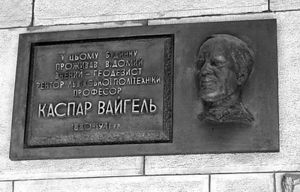
Since 1912, theGeodesy Department was headed by Professor K. Vayhel - one of the most famous geodesic scientists in Western Ukraine atthat time. His scientificinterests were diverse. The professor's work on geodesy, gravimetry and photogrammetrycontributed considerably to the further development of geodesy. He was the first to use the aerial photography results to make the maps and plans forurban areas, including Lviv. K.Vayhel was the rector of Lviv Polytechnic from 1924 to 30 and headed theGeodesyDepartment for almost 30 years. Unfortunately, he and the large group of Lviv scientists were executed by theNazis on Vuletski hills on July 3rd, 1941.
After the World WarII, in1945, the Geodesy Faculty, established in Lviv Polytechnic, included the Geodesy Department. The seniorlecturer A. Motornyi was appointed to the post of the Department head. The importantachievement of the Department at this time was the systems of polygon links withbases located not perpendicular to the line, which is defined (as in the links of parallacticpolygonometry), but along this line, designed by A. Motornyi. Such links were later named the new polygonometrylinks.
Before the invention of the lightdistance measure device, such constructions widened the possibilities of usingthepolygonometry. They were very important and their detailed analysis became thebasis for the A. Motornyi doctor thesis. At the end of his life, the professor compiled the Russian-Ukrainiantechnical terms dictionary on geodesic range of disciplines. Unfortunately, he didn'tmanage to publish it. After the Independence of Ukraine, the dictionary was considerably filled up, mainly by senior lecturerV. Litynskyi and published in 1993.
Since 1952, when the Departmentfaculty wassupplemented by the young lecturers, who graduated from Geodesy Faculty (D. Maslych, A. Ostrovskyy, L. Khyzhak, M. Drok, I.Kmetko, S. Plahotnyy, M. Kravtsov, R. Tartachynskyi and others), the Department beganstudying the impact of the environment on the results of geodetic measurements,asA. Motornyi proposed. D. Maslych studied the influence of the vertical refraction on the trigonometricleveling results in the mountains; A. Ostrovskyy investigated the effectof the lateral refraction on the accuracy of horizontal angles measuring in the urban polygonometryand the polygonometry along the rivers, railways and highways, L. Hyzhak observed the side refraction effect and triangular networks, built in flat area with heterogeneousunderlying surface (forest, tillage, sand etc.). He was the first of the Lvivland surveyors who paid attention to the dependence between variationsin images of the collimating objectives and refraction.
This connection led to an important step insolving the problem of vertical refraction; M. Drok studied the effect of thevertical refraction depending on the height of the beam (during trigonometricleveling at distances up to one kilometer) over the land and stagnant water; I.Kmetko observed the impact of the leveling refraction on the results of thehighly precise geometric leveling. Herewith the prevailing systematic but notrandom (as it was considered before) effect of refraction was proved. S.Plahotnyi investigated the rules of atmosphere influence on the light distancemeasurement; R. Tartachynskyi studied the effect of lateral refraction underconditions of the urban triangular network; M. Kravtsov observed theatmosphere influence on the radio distance measurement and M. Lisevych – itsimpact on the light distance measurement over land and water surface. B.Tlustyak explored the effect of vertical refraction in the shelf zone and V.Sazhyn – its effect of during the night period in mountain and hill areas.Assistants Yu. Fedoryschev (investigated light waves) and V. Pervaho (radiowaves) focused on the issues of atmosphere impact on the result of observingthe space position of the high objects. V. Litynskyy studied refractive fieldin large quarries - artificial salient cavities.
In 1966 the former USSR Ministry of Geology andthe Ukrainian SSR Ministry of Education jointly decided to establish the firstbranch laboratory at the Geodesy faculty for studying the atmospheric impactson astronomical and geodesic measurements. The first supervisor of thelaboratory was professor M. Myhal and the first lecturers were senior lecturersD. Maslych, A. Ostrovskyi and L. Hyzhak.
The most important scientific development of thelaboratory (1967-72) was the establishment of geodesic firing ground in theCarpathian mountain region.
Late 70s, early 80s were theyears of the Department scientific growth activity - the number of economictreaty issues has grown to 10, the capacity of work reached 200-250 thousandkarbovanets per year. In 1975 the professor M. Myhal devolved scientificleading branch laboratory upon A. Ostrovskyi.Since then, the BranchScientific and Research Laboratory№18 (BSRL-18) became an integral part of the Geodesy Department and has doneover 200 economic treaty issues. Among laboratory clients were USSR Geodesy and Cartography Main Directorate (GCMD), USSR ScienceAcademy, Ministry of Defence, Ministry of Education, the State Committee ofScience and Technology, Enterprisesof Ministry of Energy, Nuclear Energy and Gas Industry etc.
Number of faculty reached 18 people. According to refractionresearch materials of laboratory hundreds of research papers and several monographs were published, dozens of copyrightcertificates were received, 6 doctoral and almost 40 Ph.D. theses were defended(A. Ostrovskyi, P. Pavliv, B. Dzhuman, O. Moroz, F. Zablotskyi, A.Suyunov).Thus the world recognized refraction school was founded. After Ukrainehad become its Independence laboratory scientific subjects was transformed as aresult of economic and social changes. The recently founded GCMD of Ukraine hadthe urgent state problems considering land privatization, creation of modernsatellite geodesic networks, development of modern topographic technologies,setting up of a data bank and many others. The problems of engineering andgeodesic monitoring mobility of unique and large engineering buildings becamevery topical as a result of endogenous and exogenous processes. This includesnuclear, hydro and thermal power and compressor stations, gas and oil pipelineslocated in the areas of high tectonic activity, transitions from static tokinematic and dynamic geodesy, creation of permanent space astronomical andgeodetic networks of Ukraine by GPS methods; mathematical optimization of thesenetworks.
Recently the Department has madea considerable progress in the development of methods and means of providinggeodetic installation and large technological equipment repair. It turned outthat geodesic methods give you an opportunity not only to put manufacturingequipment in design position, but also to predict its duration and efficiency.And it is a new and perspective direction in engineering geodesy. Suchdevelopment brought the Geodesy Department 29 copyright certificates, seniorlecturer T. Shevchenko defended doctoral thesis and engineers V. Hrebenyuk, V.Polischuk, S. Hropot – Ph.D. ones.
In 1991 the Department publisheda monograph "Methods of incorporation of atmospheric effects onastronomical and geodetic measurements." Basic research and achievementsare based mainly on dependencies between atmosphere turbulence and refractionanomalies. In 2003 the O. Moroz's Monograph "Identification andincorporation of vertical refraction during geodesic measurements" whichbecame the basis for the doctoral thesis, defended that year.
Today 2 Sc.D and 7 Ph.D work atthe Department. The Department faculty trainsthe professionals in three Lviv Polytechnic institutes - Institute of Geodesy,Institute of Building and Environmental Engineering, Institute of Architecture.Here the lectures on Topography, Geodesy, Topographic drawing, Fundamentals ofgeodesy, Engineering Geodesy, electronic geodesic devices are given.
The Department has not onlyoptical appliances but also electronic tacheometers, electronic and laserlevels. Lessons are conducted in five laboratories and computer classroom of Department. The important direction of itsscientific activity is the consideration of atmospheric effects on the accuracyof astronomical and geodesic measurements. Lviv Refraction School, founded by Professor A.Ostrovskyi is recognized not only in Ukraine, but all over the world.
Thanks to Professor Shevchenko, who had more than 30 copyrightcertificates, the Department has made a considerable progress in thedevelopment of methods and means of providing geodetic installation and largetechnological equipment repair. Professor Shevchenko published a manual andtutorial "Geodetic devices" for the students of all geodetic profiledirections.
The professor I. Trevoho made a significant contribution to thedevelopment of the most beneficial methods of the geodesic networksconstruction under urban conditions. He suggested making at the Yavorivmilitary training ground one of the most accurate bases for testing the moderngeodesic appliances in Ukraine. The professor I.Trevoho is the President of theUkrainian Society of Surveyor and cartographers.
The senior lecturer V. Litynskyi was the first who published Geodesyencyclopaedic dictionary which consists of 3,800 articles on topography,geodesy, geodesic astronomy, space geodesy, planet geodesy, spherical geodesy,engineering geodesy, sea geodesy etc.
The senior lecturers I. Harasymchuk, Z. Tartachynska, N. Yarema, I. Pokotylo,I. Sidorov, Yu. Korduba and assistants V. Tarnavskyi, O. Serant, O. Prystupaworthily continued the best traditions of their predecessors in the scientificand educational work.
Since the foundation of Department 53 doctoral and Ph.D theses were prepared and defended, 24monographs, textbooks and over 700 research paperswere published. More than 20 years the Department is fundamental for geodesicdepartments of Western Ukraine.


